
Not as many people head to the Western part of Iceland. Sometimes it is known as “mini Iceland,” because the landscape echos the country, and it has a mountainous interior with glacier cover like the country as a whole. You can also drive a “ring road” around the perimeter, as we did today.
Our first designation was the new visitors center in Helllilssandur. It may be the sparsest visitor’s center that I’ve ever been to, anywhere in the world. At the counter there is a sign that says, “We’re here. Now what should we do?” When you scan the QR code, you get a digital image of the national park’s map. And then, in spite of the kind ranger who could answer specific questions, we were pretty much on our own to get oriented.
We made our way around a series of pretty new display signs mounted on the wall. The signs did not have maps so I just took photos so we could match them up with the digital map later.


Our first stop was Irskrabrunnur and Gufuskalar. We spent quite a while low to the ground looking at some really small plants. Even though we are at sea level, the conditions here make the vegetation similar to high alpine environments. Hands and knees botany was the rule of the day. We found half a dozen species in flower quite quickly.


Long ago, people who lived in this area fished. We walked to the ruins of a fish drying hut. The fish had to be dried to be stored for winter, and the pumice from the volcanic stones was perfect to keep the air flowing through the hut.
Drinking water would have been precious and hard to come by since wells would have been brackish if they could be dug at all in the lava fields. This spot had a well, called Irishmen’s Well, and the location had been lost to history after the last resident of the area died in the 1940s.
In 1989, a really charming event took place when the grandson of the last resident— she is referred to as “the last housewife,” and perhaps we would call her a homesteader in American English?—visited the site. He walked right up to the spot where the well was buried in the sand, hidden from site for over forty years. When the excavators began to dig, they found the steps going down. A whale bone is over the entry- then and now.


Harsh as this life must have been for the adults, it’s easy to imagine how magical it must have been for a child. Interesting to think about how he was able to locate the well. Maybe the rocks seemed familiar as land marks. We had a fun scramble over some. There was not very much sea life— one type of tiny, tiny snail, and here and there the remains of crabs.


Turning toward Gufuskalar, there is more evidence of the fishing community— it lasted from the 14th century into the mid 20th. And there is a memorial to its last resident, grandmother of the well relocator.

At this point in the day, we were feeling peckish, so turned our sights on a small cafe just outside the park, in Hellar, called Fjoruhusid. Strong coffee, tasty homemade seafood chowder with bread, and skyr cake, all served on pretty vintage china. The cafe has only half a dozen tables and we were so lucky to have one empty when we arrived. By the time we left, there was a line.
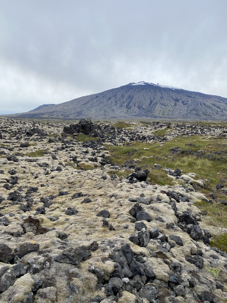
Back into the park, we were determined to find a hike of a couple of hours in length. We were interested in both the magnificent rock formations called Londrangar and the lighthouse at Malarrif. We parked at Svalpufa so we could have a walk for a few miles.

What looks like a field in the photo is actually a grass growing in a lava field. You have to select your footing with some care. The rocks are magnificent, both from a distance and once you are close. As so often happens with rocks, our discussion was about what we thought we could see in them.


When we got to it, the lighthouse was also really impressive. It is simple and stark; sort of a Frank Lloyd Wright/ arts&crafts aesthetic.


After leaving the lighthouse, we really hit the jackpot. Children in the school turned the salt house into a small interpretive center!
What a fantastic example of project-based learning. I had been impressed by the relief map at the folk museum in Heimaey, and here was another amazing example of grade school project learning.


I took so many pictures! The students had lift boards with really interesting questions about the olden days, like “Where did the drinking water come from?” and, “What did children play with?”
Hanging from the ceiling were paper mache drying fish. These had facts written on them, including how the models were made. There was an “aquarium” of models of sea life.


And there was this curious fellow, along with his interesting companion. The two were soliciting thoughts from visitors, who were asked to submit on slips of paper.


I was really very impressed! And educated from their work.
We hiked back to the car, in a bit of wind and rain, and hastened back to town in order to make our dinner reservation.
Our second world class meal in Stykkisholmur was in a restaurant named Sjavarpakkhusid. I don’t always photograph our food, but these past two nights I’ve been inspired to:


The dishes I’ll try to fake make at home were cod cheeks with rhubarb BBQ sauce and the skyr cake with rhubarb. Rhubarb BBQ sauce— of course! It’s a tangy stem vegetable and makes a great savory sauce. Although the word “cake” gets used with skyr deserts, they are more like yogurt parfaits. Again, rhubarb was the perfect foil for the creaminess of skyr.
As for the plant of the day, the winner is sea campion! It was mostly finished flowering and my phone was right on the ground to get this picture. I wasn’t expecting a good result, but it has won me over.

As a bonus, some geology of the day, with the caveat that we may be wrong. We’re consulting, but here’s the hypothesis:
Iceland is really fun for geology because you can see a whole bunch of processes and formations in a pretty small space. As we were coming back over the grassy lava field, we hit a patch of smooth large stones— sort of like you’d see above tree line.
There were striations in the rock, and Mark started to wonder if they were caused by glaciation in the last ice age. So, I took out my compass to see if they were oriented pretty much north-south. And they were, pretty much. About 30 degrees off at most. Here’s our data:

We’ve sent the photos off to our friendly geologist and we’ll see what she says. I’ll report back when I know more.


3 Responses
Your interest in everything is inspiring. Can you pronounce the names of these places?
I can pronounce almost none of them. English speakers are used to short words. We both keep starting to sound place names out and then fading. It takes longer to blog because I keep having to look up spellings.
What a fantastic adventure!